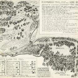
Evergreen Nature Trail Guide: evergreen trail map and work sheet (3.24663)
Date: 1940sCreator: Watts, May Theilgaard
Type: Document
Description:Original illustrations and layout for the Evergreen Trail Map and Work Sheet planned to accompany The Morton Arboretum Evergreen Trail Guide booklet. Signed "by M. T. Watts" in bottom right corner.
Work sheet in top right corner included to test your conifer knowledge. Bottom left list of plants along the trail used in conjunction with worksheet in top right corner.
Illustrated map includes names of plants along the trail as well as numbers referring to explanations in the Guide booklet.
Extent: 1 sheet
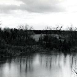
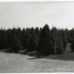
Looking south across Sterling Pond from Cricket Hill. Road on right becomes Evergreen Drive. (3.2980)
Date: circa 1960 – 1979Creator: Helmick, William K.
Type: Photographic image
Description:Looking south across Sterling Pond from Cricket Hill. Road on right becomes Evergreen Drive.
Extent: 1 photograph
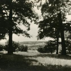
View from big oak area east of Lakeview Drive looking over Lake Marmo & Spruce Hill to Tate Woods in distance (3.3014)
Date: 1930sType: Photographic image
Description:View from big oak area east of Lakeview Drive looking over Lake Marmo & Spruce Hill to Tate Woods in distance
Extent: 1 photograph
Spruce Hill from bridge at Lake Marmo (3.3020)
Date: 1942Creator: Arden, Richard J.
Type: Photographic image
Description:Spruce Hill from bridge at Lake Marmo
Extent: 1 photograph
Spruce Hill at intersection just west of Lake Marmo dam and bridge (3.31934)
Date: 1940sType: Photographic image
Description:Spruce Hill at inersection just west of Lake Marmo dam and bridge
Extent: 1 photograph

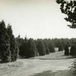
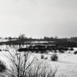
Arboretum road heading straight toward poplar tree test area, south of Spruce Hill (3.32129)
Date: 1930sType: Photographic image
Description:Arboretum road heading straight toward poplar tree test area, south of Spruce Hill
Extent: 1 negative

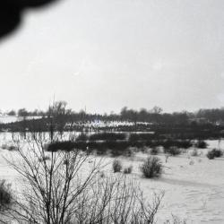
Arboretum road through poplar tree test area, south of Spruce Hill (3.32130)
Date: 1930sType: Photographic image
Description:Arboretum road through poplar tree test area, south of Spruce Hill
Extent: 1 negative

Arboretum road approaching poplar tree test area, south of Spruce Hill (3.32131)
Date: 1930sType: Photographic image
Description:Arboretum road approaching poplar tree test area, south of Spruce Hill
Extent: 1 negative

View of Cedar Point from Spruce Hill, Lake Marmo in center (3.33990)
Date: 1920sType: Photographic image
Description:View of Cedar Point from Spruce Hill, Lake Marmo in center
Extent: 1 negative
View from Spruce Hill toward Cedar Point and Lake Marmo (3.34013)
Date: circa 1920Type: Photographic image
Description:View from Spruce Hill toward Cedar Point and Lake Marmo
Extent: 1 negative filmstrip

General Information and Guide Map of The Morton Arboretum (3.34267)
Date: 1941Type: Map
Description:Doublesided brochure with general information and a guide map of The Morton Arboretum.
Guide map details Arboretum roads, trails, parking, plant collections, buildings and points of interest. Fifteen areas on the grounds highlighted in the key and identified with circled numbers on the map. Surfaced roads, gravel roads, and paths distinguished on the map by the type of line drawn. Compass showing directions north, south, east, west as well as scale indicator above top center of map.
Reverse side provides general information about the Arboretum, rules and regulations, and information about the Arboretum publication, Bulletin of Popular Information.
Extent: 1 sheet

General Information and Guide Map of The Morton Arboretum (3.34268)
Date: 1942Type: Map
Description:Doublesided brochure with general information and a guide map of The Morton Arboretum.
Guide map details Arboretum roads, trails, parking, plant collections, buildings and points of interest. Vegetation illustrated throughout map. Three stylized trees under compass showing directions north, south, east, west as well as scale indicator above top center of map.
Reverse side provides general information about the Arboretum, rules and regulations, outstanding features, buildings, Arboretum publications, and location.
Extent: 1 sheet

A Guide Map of The Morton Arboretum (3.34269)
Date: 1969Creator: Tyznik, Anthony
Type: Map
Description:A guide map of The Morton Arboretum created by Tony Tyznik in 1969. The background is a dark green with the inner Arboretum being a light green and Arboretum roads highlighted in solid orange and checkered orange lines.
Extent: 1 sheet

Map & Visitor Guide, The Morton Arboretum (3.34271)
Date: 1982 – 1986Type: Map
Description:Double-sided brochure, Map & Visitor Guide for The Morton Arboretum
Map details Arboretum roads, trails, plant collections, buildings and boundaries. Includes photographs of various Arboretum buildings with descriptive information.
Reverse side provides general information about the Arboretum, trails for walking and hiking, driving through the Arboretum, areas and collections of special interest, native plant communities, wildlife at the Arboretum, regulations, facilities and services, and information on membership. A section of the map is enlarged to identify landmarks around the Visitor Center, Administration Building, and Thornhill Education Center.
Extent: 1 sheet

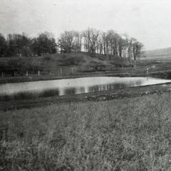
Lake Marmo viewed from Spruce Hill (3.36849)
Date: 1923Type: Photographic image
Description:Lake Marmo viewed from Spruce Hill
Looking NW to old picnic area (2 cottages then built in 1923 by Cary Reed (our first carpenter) & used as living quarters for Arboretum employees (straw bosses: 4-6 men). Site of former sheep shed where Yale & Regan kept mules)
Extent: 1 negative

Looking east from Spruce Hill (3.37815)
Date: 1926Type: Photographic image
Description:Looking east from Spruce Hill toward Cedar Hill and Lake Marmo
Extent: 1 negative
Looking west from Cornus Collection to Spruce Hill, Cedar Point on the right (3.38271)
Date: 1930sType: Photographic image
Description:Looking west from Cornus Collection to Spruce Hill, Cedar Point on the right
Extent: 1 negative
Looking west from Cornus Collection to Spruce Hill, Cedar Point on the right (3.38272)
Date: 1930sType: Photographic image
Description:Looking west from Cornus Collection to Spruce Hill, Cedar Point on the right
Extent: 1 negative