Woody Plant Collections, The Morton Arboretum, Map & Guidelines for Locating Plants [1990] (3.5822)
Date: 1990Creator: The Morton Arboretum
Type: Document
Description:Informational leaflet published by The Morton Arboretum, printed on both sides of single folded sheet, with text describing the Woody Plant Collections, the catalog, how to use the map and grid on reverse side, and how to read plant labels.
Extent: 1 sheet
Visitor Center Parking Lot [topographic] Survey (3.5271)
Date: March 20 1989Creator: Hootman, Rick
Type: Map
Extent: 1 sheet
Woody Plant Collections, The Morton Arboretum [Collections Grid, by Ronald M. Coulter and Nancy Hart Stieber, 1990, base map of roads and parking lots] (3.5825)
Date: 1990Creator: Coulter, Ronald M.
Type: Map
Description:An updated map used in the informational leaflet titled: Woody Plant Collections of The Morton Arboretum, Map & Guidelines for Locating Plants
This version only shows base map of roads and parking lots.
Extent: 1 sheet
Coord. Sketch for Park Blvd. Entrance & Parking (3.7097)
Date: June 26 2001Creator: Mehaffey, Scott A.
Type: Plan
Description:Circulation study for new entry road and relocated Forest Road through near East Side. Early concept for entry road and underpass realignment, with studies for Meadow Lake and Arbor Court S.M.
Extent: 1 sheet
Research Parking Lot Landscape Plan & Plant List (3.31998)
Date: September 3 2004Creator: Pelkonen, Peggy
Type: Plan
Description:Includes list of trees, shrubs and ground covers to plant. Plan indicates existing trees and shrubs to remain.
Extent: 1 sheet
A Guide Map of The Morton Arboretum, Lisle, Illinois [1958? with written notes on road development] (3.5995)
Date: circa 1958Creator: Tyznik, Anthony
Type: Map
Description:Probably prepared for collateral use in the Arboretum's informal series titled: Map & Visitor Guide.
Includes misc notes by C.E. Godshalk on road building and lakes.
Extent: 1 sheet
[Proposed New Frontage Road with Expanded Staff Parking Lot] (3.7098)
Date: March 20 2001Creator: Mehaffey, Scott A.
Type: Plan
Description:Shows early concepts for expanded staff parking, Main Parking, and Visitor Center Forecourt. S.M.
Extent: 1 sheet
A Guide Map of The Morton Arboretum, Lisle, Illinois [1958? with written notes on major planting dates since 1922] (3.5996)
Date: circa 1958Creator: Tyznik, Anthony
Type: Map
Description:Probably prepared for collateral use in the Arboretum's informal series titled: Map & Visitor Guide.
Includes misc notes by C.E. Godshalk on major planting dates since 1922 for various collections and landmarks.
Extent: 1 sheet
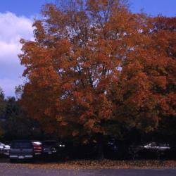
Acer saccharum (sugar maple), fall color, habit (3.38020)
Type: Photographic image
Description:Acer saccharum (sugar maple), full view of tree with evenly-proportioned egg shape and some branches visibly bare from falling leaves, with remaining foliage showing bright red and orange fall color; tree situated near a paved parking lot
Extent: 1 slide
A Guide Map of The Morton Arboretum, Lisle, Illinois [1958? with written notes regarding land purchases and use] (3.5997)
Date: circa 1958Creator: Tyznik, Anthony
Type: Map
Description:Probably prepared for collateral use in the Arboretum's informal series titled: Map & Visitor Guide.
Includes misc notes by C.E. Godshalk regarding land purchases and use.
Extent: 1 sheet
Woody Plant Collections, The Morton Arboretum [by Ronald M. Coulter and Nancy Hart Stieber, film negatives] (3.7121)
Date: 1982Creator: Coulter, Ronald M.
Type: Map
Description:Five film negatives of different parts of the final map.
The map appears on the verso of the informational flier titled: Woody Plant Collections of The Morton Arboretum: Map & Guidelines for Locating Plants. On recto of flier a narrative description of the collections is given, together with directions on how to locate plants using the collections grid, and index to the collections. Various sizes and formats of the map only are available in the collection: reproductions on paper and in transparency and photographic negatives (various sizes, scales, and formats).
Extent: 5 negatives
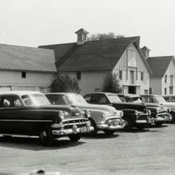
South Farm buildings behind parking lot full of cars (3.38473)
Date: 1950sType: Photographic image
Description:South Farm buildings behind parking lot full of cars
Extent: 1 filmstrip
[Plan of Development for Morton Arboretum, Lisle, Illinois, with preliminary collections grid and Arboretum's location with reference to northeastern Illinois] (3.5776)
Date: circa 1935Type: Map
Description:One of 3 closely related maps, untitled and undated, developed during the mid-1930s.
This map may have been prepared for collateral use in the Arboretum's informal series titled: Map & Visitor Guide. It contains schematic depiction of major plant collections, roads, and trails. This map also uniquely shows the collections grid in a preliminary format. A small diagram is also included in the upper right corner showing the Arboretum's location with reference to northeastern Illinois.
"Cross section map whole Arboretum" written in pencil on back of map.
Extent: 1 sheet
A Space Use Plan for the Morton Arboretum, Lisle, Illinois (3.6134)
Date: October 1986Creator: Tyznik, Anthony
Type: Plan
Description:First issued April 06,1982. Shows structures, roads, parking, and plantings extending north from the Tollway berm to the Research Building and the Hedge Garden. The proposal was subsequently modified for the reconstruction and paving carried out in the South Farm area.
Extent: 1 sheet
[Plan of Development for Morton Arboretum, Lisle, Illinois, some landmarks numbered 1-15] (3.5778)
Date: circa 1935Type: Map
Description:One of three closely related maps, untitled and undated, developed during the mid-1930s.
This map shows major plant collections, boundaries, roads, and trails in line drawing. Some landmarks on map are numbered 1-15, but no key is drawn alongside the map to identify the numbered areas.
"Plan of Arboretum" written in ink on back of map.
Extent: 1 sheet
[Guide Map of The Morton Arboretum, Lisle, Illinois, 1940s?] (3.6814)
Date: 1940sCreator: Godshalk, Clarence E.
Type: Map
Description:Map mounted on cardboard, labels pasted on, no title, "C. Godshalk" on reverse.
Extent: 1 sheet
The Morton Arboretum General Information [1950? with additional area drawn in on guide map] (3.5779)
Date: circa 1950Type: Document
Description:Copy of The Morton Arboretum General Information leaflet, with Guide Map, an issuance in the Arboretum's informal series currently titled: Map & visitor guide, printed on both sides. Guide map printed on back of sheet and includes additional area drawn in pencil including Shrub Collection, Hedges, Nursery, Brush, and Pasture.
Extent: 1 sheet
The Visitor Center Parking Lot Modification, The Morton Arboretum, Lisle, Illinois (3.6826)
Date: circa 1989Creator: Tyznik, Anthony
Type: Plan
Extent: 1 sheet
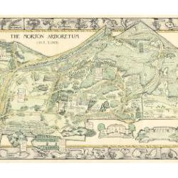
Morton Arboretum Map (3.19479)
Date: 1943Creator: Watts, May Theilgaard
Type: Map
Description:2014 reprint of The Morton Arboretum's first color map, circa 1943.
Detailed map of Arboretum grounds, showing roads, paths, landscaping, shelters, structures, enlargement of some specific features, hedge garden, some specific trees, and trails with markers numbered 1 - 42. Other features include a scale, a calendar, and a compass rose consisting of directions depicted with leaves. A highly ornamental border includes grid marks, as well as drawings of animal tracks and detailed drawings and labels of plants. The Morton Arboretum encompassed 813 acres at time of map.
Extent: 1 sheet
A Guide Map of The Morton Arboretum, Lisle, Illinois [1958? with roads and parking colored] (3.5780)
Date: circa 1958Creator: Tyznik, Anthony
Type: Map
Description:The map was probably designed for collateral use in the Arboretum's informal series titled: Map & visitor guide. Roads showing direction of traffic and parking areas have been colored in with colored pencil.
Extent: 1 sheet
A Guide Map of The Morton Arboretum, Lisle, Illinois [1958? with updates] (3.5781)
Date: circa 1958Creator: Tyznik, Anthony
Type: Map
Description:Probably prepared for collateral use in the Arboretum's informal series titled: Map & Visitor Guide. The map has been updated by mounting a small mylar sheet on the left margin. The addition shows the Sterling Pond and nearby areas. Roads, lakes, and parking have been colored in colored pencil.
Extent: 1 sheet
Research Parking Lot Improvements - 1994 (3.6201)
Date: May 1 1994Creator: Mehaffey, Scott A.
Type: Plan
Description:Planting list for the Research Parking Lot.
Extent: 1 sheet

Morton Arboretum Map: Preliminary Drawing for Colored Map (3.19480)
Date: 1943Creator: Watts, May Theilgaard
Type: Drawing
Description:Preliminary drawing for detailed colored map of Arboretum grounds that was printed in 1943, showing roads, paths, landscaping, shelters, enlargement of some specific features, hedge garden, and center of hedge garden. Blank spaces indicate water and text placement. Tree symbols show exceptional specimens on east and west sides. The Morton Arboretum encompassed 813 acres at time of map. Drawing is in two pieces.
Extent: 2 sheets
Woody Plant Collections, The Morton Arboretum [by Ronald M. Coulter and Nancy Hart Stieber] (3.5809)
Date: 1982Creator: Coulter, Ronald M.
Type: Map
Description:The map (in color) appears on the verso of the informational flier titled: Woody Plant Collections of The Morton Arboretum: Map & Guidelines for Locating Plants. On recto of flier a narrative description of the collections is given, together with directions on how to locate plants using the collections grid, and index to the collections. Various sizes and formats of the map only are available in the collection: reproductions on paper and in transparency and photographic negatives (various sizes, scales, and formats).
Extent: 1 sheet
Map and Visitor Guide [of] The Morton Arboretum [by Nancy Hart Stieber and John Sosnowski, landmarks and vegetation portion] (3.6533)
Date: 1984Creator: Hart, Nancy
Type: Map
Description:Transparencies used in production of the flier showing landmarks/collections and vegetation to be used in the map portion of the informal series titled: Map & Visitor Guide. Updated in 1989 with Crabapple Lake.
Extent: Envelope with 2 items

Morton Arboretum Map (3.19481)
Date: 1943Creator: Watts, May Theilgaard
Type: Map
Description:Detailed map of Arboretum grounds, showing roads, paths, landscaping, shelters, structures, enlargement of some specific features, hedge garden, some specific trees, and trails with markers numbered 1 - 42. Other features include a scale, a calendar, and a compass rose consisting of directions depicted with leaves. A highly ornamental border includes grid marks, as well as drawings of animal tracks and detailed drawings and labels of plants. Some replacement illustration and text has been adhered to the map. The Morton Arboretum encompassed 813 acres at time of map. One section is partially missing.
Extent: 1 sheet
Map and Visitor Guide The Morton Arboretum [by Nancy Hart Stieber and John Sosnowski] (3.5818)
Date: 1984Creator: Hart, Nancy
Type: Document
Description:Leaflet created for the informal series titled: Map & Visitor Guide. On the recto of the leaflet an inset map (1 inch=1/2 mile) shows major Arboretum structures and connecting roads; also given is a summary of the Arboretum's history, public facilities and services, and regulations. Updated in 1989 with Crabapple Lake.
Extent: 1 sheet printed on both sides
Woody Plant Collections, The Morton Arboretum [Collections Grid, by Ronald M. Coulter and Nancy Hart Stieber, 1990, colored with mowing schedule] (3.6293)
Date: 1990Creator: Coulter, Ronald M.
Type: Map
Description:An updated map used in the informational leaflet titled: Woody Plant Collections of The Morton Arboretum, Map & Guidelines for Locating Plants
This version is hand colored and labeled to show mowing schedule.
Extent: 1 sheet
Map and Visitor Guide [of] The Morton Arboretum [by Nancy Hart Stieber and John Sosnowski, various sections broken down into multiple negatives] (3.5819)
Date: 1984Creator: Hart, Nancy
Type: Map
Description:Seven photographic negatives depicting various sections of the map portion for the production of the Map & Visitor Guide. Updated in 1989 with Crabapple Lake.
Extent: Envelope with 7 film negatives
[Route 53, entry road, parking lot, Meadow Lake area landscape plan] (3.31967)
Type: Plan
Extent: 1 sheet
Map and Visitor Guide [of] The Morton Arboretum [by Nancy Hart Stieber and John Sosnowski enlarged sections of landmarks and vegetation] (3.5821)
Date: 1984Creator: Hart, Nancy
Type: Map
Description:Enlarged sections of landmarks and vegetation of the map portion of the Map & Visitor Guide created for production. Updated in 1989 with Crabapple Lake.
Extent: Folio of 12 items
[Route 53, entry road, parking lot, Meadow Lake area landscape plan - colored version] (3.31968)
Type: Plan
Description:Areas highlighted in color pencil on landscape plan
Extent: 1 sheet

A Guide Map of The Morton Arboretum (3.34269)
Date: 1969Creator: Tyznik, Anthony
Type: Map
Description:A guide map of The Morton Arboretum created by Tony Tyznik in 1969. The background is a dark green with the inner Arboretum being a light green and Arboretum roads highlighted in solid orange and checkered orange lines.
Extent: 1 sheet

General Information and Guide Map of The Morton Arboretum (3.34267)
Date: 1941Type: Map
Description:Doublesided brochure with general information and a guide map of The Morton Arboretum.
Guide map details Arboretum roads, trails, parking, plant collections, buildings and points of interest. Fifteen areas on the grounds highlighted in the key and identified with circled numbers on the map. Surfaced roads, gravel roads, and paths distinguished on the map by the type of line drawn. Compass showing directions north, south, east, west as well as scale indicator above top center of map.
Reverse side provides general information about the Arboretum, rules and regulations, and information about the Arboretum publication, Bulletin of Popular Information.
Extent: 1 sheet

General Information and Guide Map of The Morton Arboretum (3.34268)
Date: 1942Type: Map
Description:Doublesided brochure with general information and a guide map of The Morton Arboretum.
Guide map details Arboretum roads, trails, parking, plant collections, buildings and points of interest. Vegetation illustrated throughout map. Three stylized trees under compass showing directions north, south, east, west as well as scale indicator above top center of map.
Reverse side provides general information about the Arboretum, rules and regulations, outstanding features, buildings, Arboretum publications, and location.
Extent: 1 sheet